Tracking Activities in New York State
Since my last post focused on all of the interstate borders, I figure it would make sense for my next one to focus squarely within the borders of my Empire State. Actually, that post is worth a revisit, since I've crossed a few state lines since then, but like many of us I've been focusing on more local travel and that national one can wait for now.
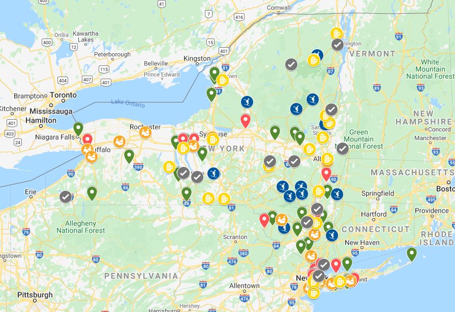
I'm sure there's a more direct way to share a Google map in Blogger, but this quick screen-grab upload should suffice. Even before the pandemic, the idea of spending time in each of New York's 62 counties had struck me. At the time of posting this, I'm up to 55 of them. Drive throughs don't count; only those where I've seen or done something like visited a National Park Service site, a New York State Park, attended a sporting event, etc, count for my purposes.
My first attempt at keeping tabs of my New York travels was with a simple outline view of the counties, where I put a checkmark in each one as I recalled doing something in it (a Yankee game let me check off the Bronx, a Bisons game let me check off Erie county, skiing Whiteface meant checking off Essex county, etc.). A cleaner version of that is near the end of this post.
It's quite possible that I've been places that I don't recall, but I'm only counting what I do. When first done tallying, I was somewhere in the 40s, but have added close to 10 more over the last year with skiing (Lewis and Hamilton counties via Snow Ridge and Oak Mountain, respectively), breweries (Schenectady and Tioga via Wolf Hollow and Farmhouse Brewery-Owego, respectively), and so on.
Getting back to the map, green pins represent state parks, red pins show NPS sites, the yellow mug icons were used for breweries, the orange "stadium" icons denote sporting venues and dark blue ski icons ski resorts. Further, a checkmark was used for other noteworthy spots that helped me fill in the map a tad more accurately through a site or activity that didn't fit into the other categories (Howe Caverns, Ausable Chasm, Cooperstown, etc).
The pinning isn't meant to be exhaustive; I mean, I've surely been to more breweries than is shown on the map, but it is just to help me contemplate where I've been and where I haven't been. Ballparks and the NPS sites helped me visit more spots in the Finger Lakes and western NY region. Curiosity about simply never recall being in the western park of the North Country region (or much of the Mohawk Valley) is what made me start paying attention to where I was going and to target these areas for some exploration. It's meant a lot of driving on more local roads, and has simply been a fun undertaking.

Again, this highway map won't be complete, but it's probably pretty close. If I had posted this map two years ago, there would be far fewer traced routes.
Sure, I'm eager to explore more of the country, but exploring my home state has been a fine fallback plan, especially at a time when staying closer to home is prudent. There are about 215 state parks in New York—no way am I considering going for all of them, but they do work well for filling an itinerary, and some of the less-visited smaller ones are rather amenable for social distancing.
My goals for NY? The first was visiting every NY NPS site, which I've done. Next was getting to every MiLB site (I've posted about this before), which I've also done. For sports, in fact I am the Sabres' rink away from visiting every pro NY team. Things like the state parks, ski resorts and breweries have been and will continue to be visited as they appeal to me. Watkins Glen and Letchworth State Parks were prime examples of that. By the time all of these spots were pinned, I knew I had visited the lion's share of the counties, and decided to see what I was missing in the others. Finally, yes, the 62 NY counties are a goal. I have ideas for the seven counties I've yet to spend time in, and hope to finish this quest within 2021, so long as I can feel safe doing it.
And here is a map of New York's counties, with those I'm currently missing circled.

Finally, a few quick thoughts on the Google My Maps. First, I dislike the lack of zooming control. If I pan out one "+", or rotate the mouse wheel one click, the map shows the icons nicely, but crops the image unwantedly. If I zoom in the other way, many of the icons overlap. Also, it seems the layers of the map are given dominance by the order I created them, with each newer layer showing over previous ones. So, the icons for my layer of "other" places sit on top of nearby state park pins, which was the first layer I made. Finally, while I play with Google My Maps for itineraries, I likely have plenty to learn about moving maps here, making it updatable, etc.


Comments
Post a Comment